The Marañón Basin is the westernmost large tributary of the Amazon River and joins the Ucayali to form the Amazon River (or “Amazonas,” as it is called in Peru). Flowing for approximately 1,400 km, the Marañón is the 11th longest tributary of the Amazon River and its basin covers 362,000 km2 and is the seventh largest in the Amazon.

Map: Wildlife Conservation Society, 2016
The headwaters of the Marañón are approximately 150 km north of Lima and approximately 100 km from the Pacific. Approximately 80 percent of the Marañón Basin is in Peru; the other 20 percent is in Ecuador. There are nine Peruvian regions (departments) and nine Ecuadorian provinces in the Marañón Basin (Ecuadorian provinces are the equivalent of Peruvian and Bolivian departments and Brazilian states). Most of the Basin’s northern drainage lies within the large Peruvian department of Loreto.
Most of the Marañón River flows through a narrow and high intermountain valley between the Cordillera Occidental and Cordillera Central. Only the lower 600 km are in the Amazon lowlands below 300 m. Before emerging from the Andes, the Marañón is marked by a series of rapids, and the most spectacular are those in the Pongo de Manseriche Gorge, which lies at 575 m. River craft of any significant size are not able to navigate most of the Marañón above Manseriche.
The longest tributary of the Marañón River is the Huallaga (about 1,000 km) that flows between the Cordillera Central and Cordillera Azul in Peru. The other large tributaries of the Marañón—the Pastaza, the Tigre, the Morona and the Santiago—arise in Ecuador. They are all less than 700 km long. The Pastaza, the largest, has headwaters near the famous Cotopaxi Volcano in Ecuador.
The lower Marañón River is turbid, whereas in most of the inter-Andean region the river is clear for about half of the year. The northern drainage of the Marañón has numerous small blackwater tributaries between the Santiago and Tigre Rivers. The lower sections of the Marañón tributaries meander extensively and have large floodplains. River-level fluctuation of the lower Marañón is similar to that of the Amazonas near Iquitos—approximately 8.5 m.
Protected Areas
Only two large areas have been designated for protection in the Marañón Basin: the Pacaya-Samiria National Reserve and the Santiago-Comaina Reserved Area.

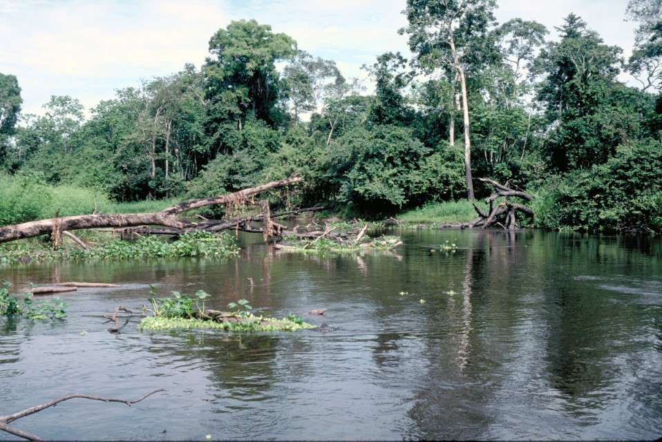
River channel and wetland forest in the Pacaya-Samiria National Reserve. Department – Country: Loreto – Perú Main Basin – Sub Basin: Marañón – Marañón Main Stem Elevation: 112 Photographer: Michael Goulding
The Pacaya-Samiria National Reserve is the second largest protected area (after Alto Purus National Park) in Peru and is also the largest protected floodplain in the Amazon Basin. It is located between the juncture of the Marañón and Ucayali Rivers and was established mainly to protect and manage aquatic wildlife. The reserve is named after two smaller rivers whose headwaters are within it. Most of the reserve is within the Marañón Basin, the smaller portion in the Ucayali drainage. It encompasses approximately 20,800 km2, nearly all of which is floodplain with at least 85 lakes. Palm swamps (especially Mauritia flexuosa) and floodable mixed forest cover most of the reserve. The reserve has been heavily logged, but there has been relatively little large-scale deforestation. Its lakes are fished to supply the large Nauta and Iquitos markets.
Somewhere between 75,000 and 100,000 people live in villages and towns around the reserve. Most of them, however, live in three large towns: Nauta along the Marañón River, Lagunas on the Huallaga River near its confluence with the Marañón, and Requena on the Ucayali River. The population inside the reserve is sparse—most communities have less than 100 people—and include a minority of indigenous groups. Most residents of Pacaya-Samiria practice subsistence agriculture, fishing and hunting and collect palm fruits for consumption and sale to urban centers.
The Santiago-Comaina Reserved Zone occupies a large area between the rivers Marañón and Morona and the crest of the Cordillera del Condor. The North Peruvian Pipeline crosses the southeastern corner of the Santiago-Comaina Reserved Zone. The Cordillera del Condor is a mountainous region that Peru and Ecuador have fought three wars over for ownership. A peace treaty ended the dispute in 1998 and part of the treaty obligates both countries to set up protected areas in the Cordillera del Condor.
The Marañón Basin has numerous indigenous areas but they are largely disconnected and relatively small, especially in comparison to those in Brazil.
Uses & Impacts
Deforestation in the Marañón Basin is most pronounced in the Huallaga Basin (a major agricultural frontier), in the area near Iquitos where there are roads and in headwater areas in Ecuador.
The Marañón Basin is rich in minerals and hydrocarbons and many concessions have been granted. There are oil wells both north and south of the Marañón River, including inside Pacaya-Samiria National Reserve. Pipelines transport crude oil from the rainforest regions across the Andes to refineries in the Peruvian coastal department of Piura. One of these, the North Peruvian pipeline from the Pacaya-Samiria National Reserve, follows the Marañón and is met by the main northern conduit just downriver of the Pongo de Manseriche Gorge. Here, the pipeline crosses the Marañón River and continues to follow it for a short distance, after which it crosses the Andes. The North Peruvian pipeline has a capacity of 200,000 barrels per day.
The settlement of the Ecuador-Peru border dispute in 1998 opened the possibility for Ecuador to transport crude oil to Peru from its border region with the northern tributaries area of the Marañón. The North Peruvian pipeline passes through regions in the Andes that are subject to earthquakes and mudslides. In 1999 the pipeline ruptured but was quickly repaired. In 2000 a barge transporting crude from the Pacaya-Samiria National Reserve went aground and released approximately 5,500 barrels of oil into the Marañón River, although the spill was apparently contained and no large-scale downstream impacts were reported.
Other than small dams in the higher driver regions used mostly for water storage and irrigation the only relatively large dam (400+ MW) is the Chaglla on the Huallaga River at about 1,200 m elevation in the Huallaga Basin. Many more dams, however, have been proposed. The largest of proposed Peruvian dams in the Andes, in or outside of the Amazon Basin, would be at the Pongo de Manseriche Gorge and it would have major downstream impacts, if unmitigated, on discharge, sediment and nutrient cycles.
-

Marañón 4
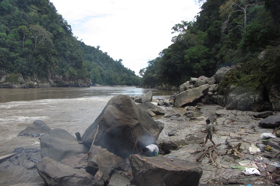
The Pongo de Manseriche is a gorge near the exit of the Marañón River from the Andes and a potential large dam site. Department – Country: Loreto – Peru Main Basin – Sub Basin: Marañón Photographer: Junior Chuctaya
MAIN RIVER BASINS
Caquetá-Japurá
Juruá
Madeira
Marañón
Napo
Negro
Purus
Putumayo-Içá
Tapajós
Tocantins
Trombetas
Ucayali
Xingu

