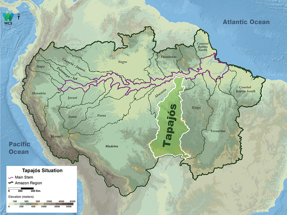
The Tapajós Basin is the fifth largest tributary basin in the Amazon and covers approximately 492,000 km2. The Tapajós Basin encompasses approximately 7 percent of the Amazon Basin.
Its headwaters are almost 2,700 km from the Amazon River mouth and nearly reach Cuiabá, the capital of Mato Grosso, in Central Brazil. The mouth of the Tapajós River is approximately 800 km from the Amazon River mouth. More than 95 percent of the Tapajós Basin is divided between the states of Mato Grosso and Pará, with the states of Amazonas and Rondônia skirting the western drainage. For at least two decades, political movements have been underway to create the state of Tapajós in a large part of the Tapajós Basin.
The Tapajós Basin lies mostly on the Brazilian Shield and within the Amazon rainforest zone. Headwaters arise in the central Brazilian scrub savanna less than 200 km from the giant Pantanal swamp. Average annual precipitation is approximately 2,300 mm. There is a pronounced three- to four-month dry season. The rainy season in the upper Tapajós Basin begins in late September, whereas in the lower Basin it begins in late December or January. The peak of the annual floods in the middle and upper Tapajós Basin is usually in March. Near the Tapajos River mouth, the highest water levels are normally in May or June. This is because water levels in the lower river are controlled by the Amazon River. Annual river-level fluctuation of the Tapajós and its two main tributaries, the Juruena and the Teles Pires, averages 4–5 m. The ranges between the highest known floods and lowest river levels are 8–9 m.
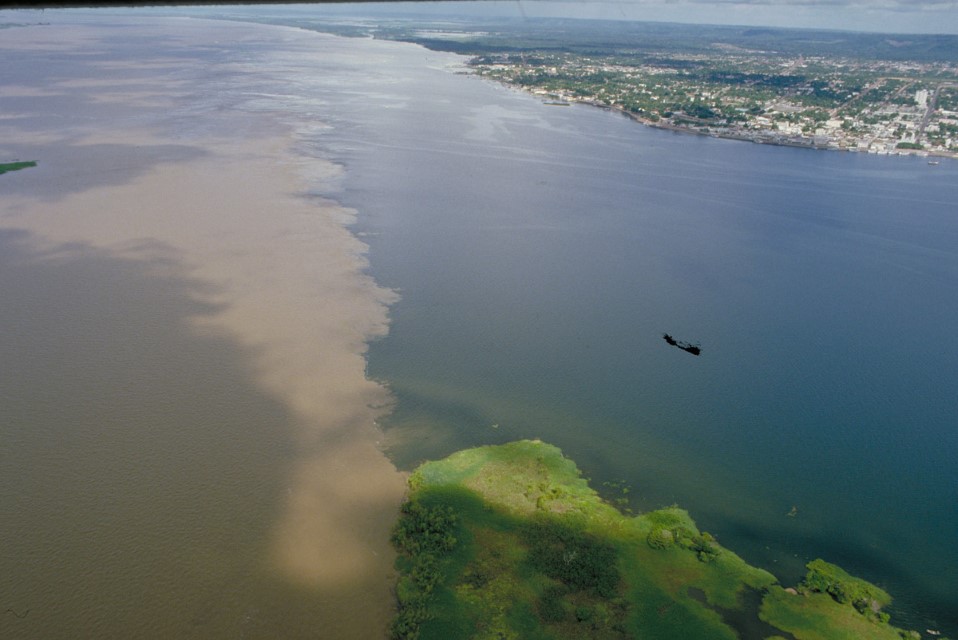
Most tributaries of the Tapajós flow through the relatively high terrain of the Brazilian Shield. Hilly regions, such as the Serra do Cachimbo, Serra dos Caiabis and Serra do Tombador, are drained by the Juruena and the Teles Pires. The first major cataracts on the Tapajós River are near Itaituba, approximately 200 km from its mouth. Migratory fish, however, are able to pass these rapids. Numerous rapids stud the middle and upper Juruena and Teles Pires Rivers. The lower Juruena has floodable forests and there are small low-lying areas subject to seasonal inundation scattered throughout the Tapajós Basin. As with the Tocantins and Xingu Rivers, the Tapajós has a giant mouth-lake bordered by relatively high cliffs and low beaches. The beaches are inundated for six months each year and support sandy-flooded-forest species such as wild cashew (Anacardium spp.). In the mouth region of the Tapajós, turbid water, clear water and black water exist in close proximity. The blackwater Arapiuns, a left-bank tributary, drains sandy soils and flows into the clearwater Tapajós near its confluence with the Amazon River.
Protected Areas
Relatively few areas are designated for strict protection in the Tapajós Basin. Among them, national forests are probably the most important protected areas. Most are in the lower drainage and gold miners, squatters, or loggers have invaded them. Indigenous lands are mostly in the middle and southern western side of the basin. No significant areas around headwaters are protected. The headwater region of the Tapajós River has largely been converted into pastureland and cropland. The right bank of the Arapiuns is designated as protected but is an area of heavy logging. The Arapiuns River near the mouth of the Tapajós deserves special attention because it is the easternmost relatively large blackwater river in the Amazon Basin.
Uses & Impacts
The Santarém-Cuiabá and Trans-Amazonian highways opened the Tapajós Basin to large-scale development in the 1970s. The former is now paved and both highways have been used as arteries for cattle ranching, gold mining, logging and soybean farming. Current transportation project proposals include an industrial waterway and a railway between Cuiabá and Santarém to export agricultural products from Central Brazil. Constructing the industrial waterway, called Hidrovia, would require channel deepening and excavation of cataracts.
Gold mining has impacted the Tapajós Basin since the early 1970s and has been mostly concentrated in the auriferous area between the Tapajós, Jamaxim and Teles Pires rivers. Most gold was extracted from alluvial deposits. The number of small streams excavated for gold is unknown, but it probably was in the thousands. Tapajós gold mining created two principal environmental problems, the destruction of clearwater streams and mercury pollution. Fish species living in the Brazilian Shield tributaries of the Tapajós appear to have evolved in clear water. High turbidity would probably kill them though the streams mined in the 1980s may have been recolonized, though studies are lacking to verify this. The fate of the mercury used for gold mining in the Tapajós Basin is not clearly known. The huge mouth-bay is the main deposition zone for the Tapajós River and some mercury may be buried there. Sediment loads were greater during the 1980s because of the disposal of mine tailings into the streams. The length of time that Tapajós sediments might remain in the mouth-bay is not known. The formation of islands, however, suggests that it could be decades if not centuries in some stretches. Buried mercury will perhaps be carried slowly downstream in sediments and discharged into the Amazon River.
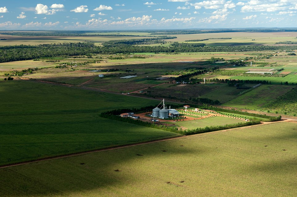
With the decline of the gold rush, entrepreneurs in the middle and lower Tapajós Basin began to invest heavily in cattle ranching and logging and more recently in soybean farming. Itaituba, on the Trans-Amazonian highway, was transformed from a gold-driven economy to a cattle and logging center. Itaituba is located in a narrow part of the Tapajós Basin and deforestation is advancing westward along the Trans-Amazonian highway into the Madeira Basin. Landscape alteration in the Tapajós Basin is most noticeable in the Mato Grosso headwater region along the Santarém-Cuiabá highway and near the city of Peixoto de Azevedo on the Teles Pires. The latter area is in the heart of the central Brazilian agricultural frontier, from which soybean farming has rapidly expanding northward. Soybean farming, however, has reached as far as Santarém at the confluence of the Amazon and Tapajós rivers. Santarém is now the main soybean ship-loading port for soybeans produced in the Amazon Basin or contiguous Cerrado.
The Tapajós probably has the highest hydroelectric potential of any major Amazon sub-basin. Numerous dams are planned for not only the main river but also several tributaries, especially in the headwater region of the Teles Pires and Juruena rivers.
-
Tapajos 1
The confluence of the clearwater Tapajós River and the Amazon River near Santarém. Department – Country: Pará – Brazil Main Basin – Sub Basin: Amazon Main Stem – Eastern Amazon Main Stem Photographer: Michael Goulding
-
Tapajos 2
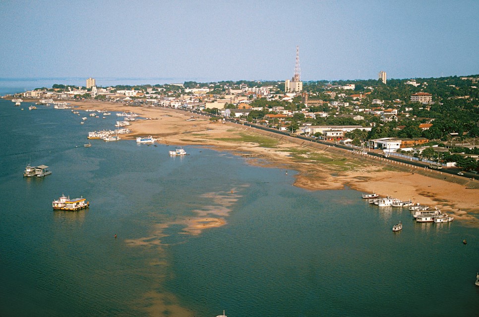
Clear waters of the Tapajós River along the Santarem waterfront during the low water period. Department – Country: Pará – Brazil Main Basin – Sub Basin: Amazon Main Stem – Eastern Amazon Main Stem Photographer: Michael Goulding
-
Tapajos 3
Large-scale soybean farming is impacting upper Tapajós Basin. Department – Country: Rondônia – Brazil Main Basin – Sub Basin: Tapajós – Jurena Photographer: Luiz Claudio Marigo
-
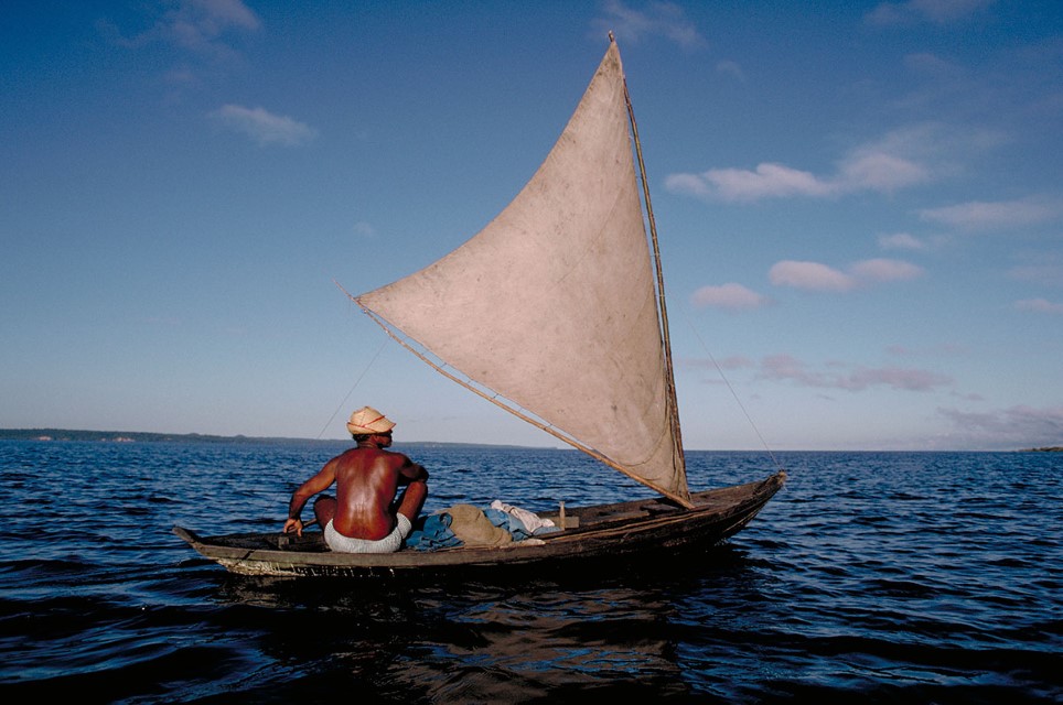
Tapajos 4
The Tapajós River mouth-bay resembles a large lake. Department – Country: Pará – Brazl Main Basin – Sub Basin: Tapajós Photographer: Michael Goulding
MAIN RIVER BASINS
Caquetá-Japurá
Juruá
Madeira
Marañón
Napo
Negro
Purus
Putumayo-Içá
Tapajós
Tocantins
Trombetas
Ucayali
Xingu
