Launched in July 2018, the Ictio platform concludes its management phase with the Cornell Lab of Ornithology (CLO), and its data will now be integrated into the Amazon Waters Observatory. Developed by CLO in collaboration with the Wildlife Conservation Society (WCS) and members of the Amazon Waters Alliance, Ictio became, over these eight years, a platform for generating, bringing together, and sharing information on fish and fisheries across the Amazon Basin.
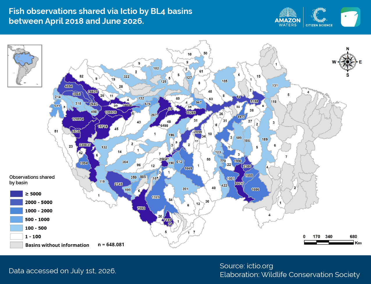
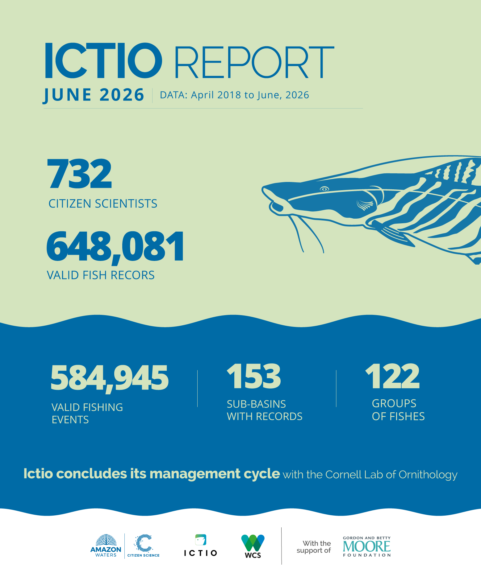
Figure 1. As of June 30, 2026, when the Cornell Lab of Ornithology formally concluded its management of the Ictio database, the platform had compiled 648,081 fish records from 584,945 checklists (fishing events). These records cover 153 (77%) of the 198 fourth-level sub-basins of the Amazon Basin.
Ictio gathers information from 153 fourth-level (BL4)* sub-basins across the Amazon Basin. Among the ten sub-basins with highest records (Figure 2), Ucayali, in Peru, stands out with more than 239,000 records. Also in Peru, the Amazonas upstream Jandiatuba sub-basin has the highest number of records submitted through the Ictio applications, thanks to data contributed by fishers and citizen scientists based on their fishing activities.
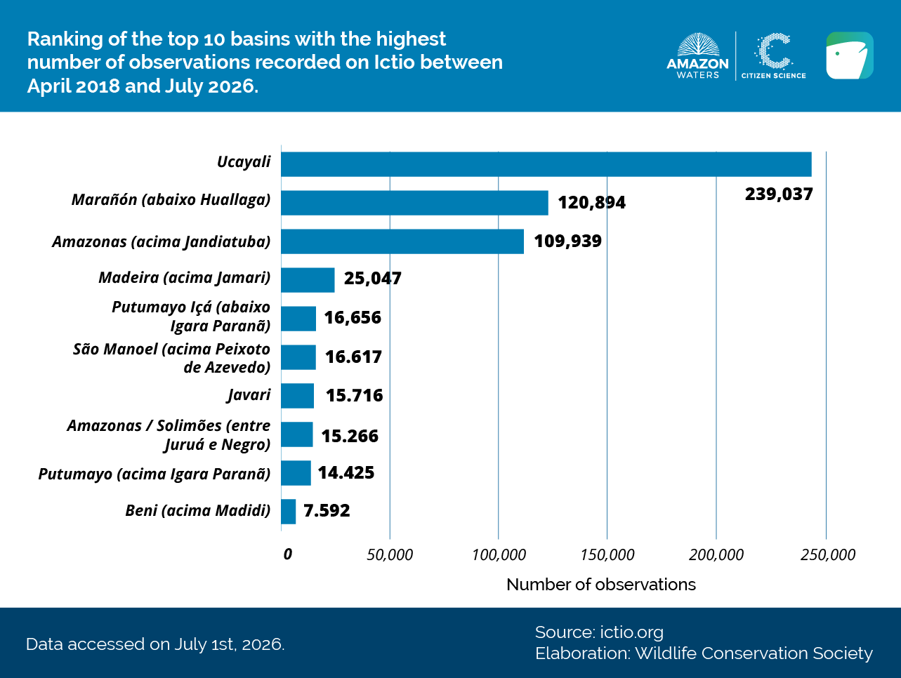
Figure 2. BL4 sub-basins with the highest number of records in Ictio as of June 30, 2026.
Ictio closes this cycle with 732 contributors, including government institutions, research centers and universities, researchers, Indigenous and fishers’ associations, women fishers, and other stakeholders. Their participation helped build a database that brings together information generated through academic and citizen science, providing evidence to support the understanding and management of fisheries resources.
Among the 732 contributors, three experiences illustrate the diversity and scale of the contributions that made it possible to build this database: government institutions that incorporated historical monitoring series; academic institutions and organizations that integrated information from different sources.
(i) Direpro-Loreto, a government institution based in Iquitos, Peru, contributed more than 500,000 records from its database, compiled over more than 10 years of fisheries production monitoring;
(ii) the Federal University of Rondônia (UNIR) and Ecoporé, both based in Porto Velho, Brazil, shared information from continuous fisheries monitoring at ports in the region, as well as data generated by schools, artisanal and recreational fishers, collected through different applications; and
(iii) the Federal University of Mato Grosso (UFMT) and the fishers’ association Colônia Z-16, both based in Sinop, Brazil, published more than 26,000 fish transport records collected by the Colônia in the Tapajós Basin, one of the regions with the lowest representation in fisheries statistics.
The contributions of grassroots organizations, Indigenous peoples, and fishers’ associations represent another fundamental dimension of this stage of Ictio. Through participatory monitoring activities and the recording of their own fishing activities, these stakeholders incorporated information generated directly in the territories, complementing the database with valuable contributions from citizen science. These include:
(i) the Puma Garza I Fishers’ Association and fishers from the Tahuayo River area in Peru, who, with the support of WCS Peru, contributed more than 11,000 records of their fishing activities, many of them through the Ictio application;
(ii) various associations from the San Buenaventura and Rurrenabaque region in Bolivia — including the Paiche and El Sábalo fishers’ associations; and Quetcha and Jai Hu, Indigenous peoples associations— as well as Indigenous communities from the Tacana and San José de Uchupiamonas Communal Lands of Origin, which, with the support of WCS Bolivia, contributed records through Ictio Anecdata;
(iii) fishers from the Ichilo River in Bolivia, who, with the support of Faunagua, have recorded their activities for more than 20 years and shared this information with Ictio; and
(iv) the Napo River Artisanal Fishers’ Association and the Indigenous people of Shuar Kaputna Center, who, supported by WCS Ecuador, shared information through the Ictio app and, more recently, SMART Ictio; helping document new fish species in Ecuador.
We celebrate and thank all the citizen scientists who contributed to Ictio! Their records provided unprecedented and highly valuable information for expanding knowledge about fish in the Amazon Basin and complemented data generated by research institutions, government agencies, and other stakeholders. The quality and value of these contributions have also been supported by analyses using Ictio data. Citizen science records helped expand the known distribution ranges of commercially important migratory species, such as large catfish of the genus Brachyplatystoma (Figure 3). Read more here.
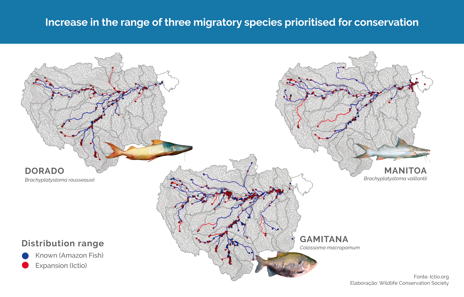
Figure 3. Ictio citizen science data expanded the known distribution range of threatened fish species of high commercial importance in the region.
Species recorded
Of the 122 species/species groups recorded in Ictio, the bocachico (Prochilodus nigricans) stands out with 88,345 records, followed by palometas (Mylossoma sp.), with 36,787 records, and sardines (Triportheus sp.), with 29,953 records (Figure 4).
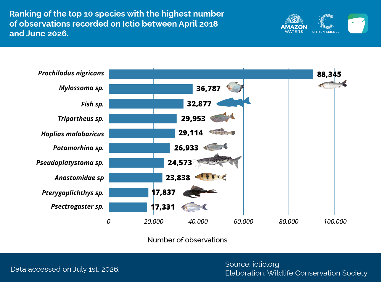
Figure 4. Species/species groups with the highest number of records in Ictio as of June 30, 2026.
The category “other fishes”, which groups species not included on the platform, accounts for 32,365 records. Ictio allowed users to record 130 species or groups on the platform and 30 through its application. This high number of records classified as “other fishes” reflects, among other factors, the enormous diversity of species in the Amazon Basin, including species of commercial interest. The new infrastructure will expand the possibilities for recording and accessing information about species described for the Amazon Basin.
Ictio and the future Amazon Waters Observatory
Building on the lessons learned and experience gained through Ictio, the Amazon Waters Observatory will integrate and share its data with the Global Biodiversity Information Facility (GBIF), an international network funded by governments around the world, that makes open biodiversity data available. The Observatory is currently in its final stage of development and, once operational, will be managed by WCS, the host organization of the Amazon Waters Alliance.
The new structure will improve access to information for researchers, decision-makers, and public-sector managers. It will also increase the visibility of organizations that publish data, and enable the tracking of data use. At the same time, the Ictio platform’s policy on access to and protection of sensitive information will be maintained, while new data management agreements are developed. The Amazon Waters Observatory will also feature an easy-to-navigate dashboard that will make information accessible to the general public.
It is important to highlight the support of the Gordon and Betty Moore Foundation for the development of these initiatives, which contribute to understanding how fish migrations function across the Amazon Basin and strengthen the integrated management of its fisheries resources. This support has been instrumental in advancing processes that bring together data generation, citizen science, and the development of tools to improve knowledge of Amazonian aquatic ecosystems.
* (For more information on the basin classification used by Ictio, see Venticinque et al., 2016 – ‘New Geographic Information System (GIS) on rivers and basins for the conservation of aquatic ecosystems in the Amazon’).
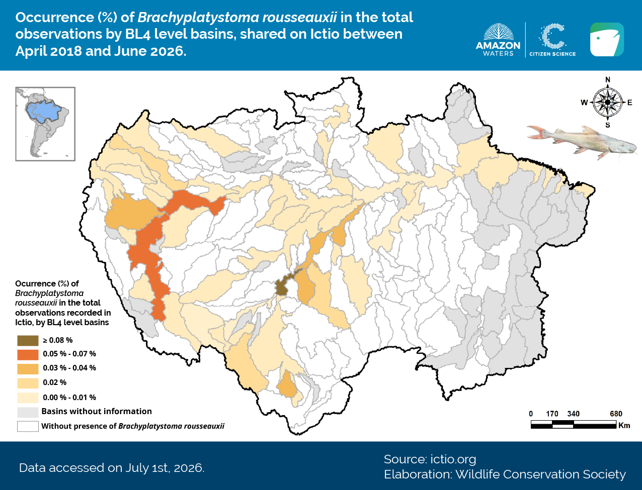
GLOSSARY
Checklists: Lists of fish caught in a fishing event.
BL4 Basins: Basin level 4 is the scale that delineates all tributary sub-basins between 10,000 km² and 100,000 km².
Observations: Records of species/groups of fish species caught in the Amazon Basin.
Users: Amazonian citizens using the ICTIO application or platform, consisting mainly of local and indigenous peoples, individual fishers, management groups, associations of fishermen, and scientists.
This note is made possible thanks to the support of the Gordon and Betty Moore Foundation. The content is the responsibility of the Wildlife Conservation Society and does not necessarily reflect the views of the Moore Foundation.